Star-Gazing for the Sea-Faring Soul
A Brief History of the Nautical Almanac, updated for Digital First sailing
Sailing offshore has never been for the faint of heart. Imagine setting off into the unknown with your wits, a sextant, and a disturbing lack of Wi-Fi. It makes modern sailors shudder as they check their position for the tenth time in a minute. But long before satellites and chartplotter screens, mariners relied on the oldest reference point of all. The sky. Then, later, the Nautical Almanac.
The early days: “Where in Neptune’s name are we?”
Before charts and reference books, sailors had a rough deal. The stars were always up there, but making sense of them took more than a keen eye and dramatic horizon squinting. Ancient civilisations like the Phoenicians and Greeks used celestial navigation with limited tools and limited theory. Latitude was the first win. If Polaris was higher, you were further north. If it was lower, you were further south. It was crude, but it worked.

Then came the Age of Exploration. A glorious time of discovery, questionable hygiene, and an impressive number of people getting lost. By the 15th and 16th centuries, mariners used tools like the astrolabe and quadrant. Great for latitude. Useless for longitude. A ship could be “on course” and still end up hundreds of miles off because nobody could reliably track east to west position. Many sailors probably cursed the heavens while their ship “discovered” another island they did not mean to find.
The longitude problem: a pain in the astrolabe
Longitude needed precise timekeeping. Latitude was simple enough. Measure the sun or a star above the horizon. Longitude demanded you know the time difference between where you were and a known reference. At sea, keeping time accurately was about as easy as keeping a candle steady in a gale.
For centuries, navigators tried lunar distances. Measure the angle between the moon and another celestial object, then use maths to infer time and position. The problem was not only the maths. It was doing that maths on a deck that moved like an angry trampoline.
The need was so urgent that in 1714 the British government offered the Longitude Prize, £20,000 to anyone who could stop sailors arriving in the wrong ocean. That prize helped bring forward John Harrison’s chronometers, and also pushed improvements in astronomical methods that could make even a keen mathematician feel tired.
The birth of the Nautical Almanac: “Look it up, sailor”
Enter the 18th century, an era of wigs, wars, and practical thinking. Nevil Maskelyne realised something simple. If navigators had precomputed tables showing the positions of celestial bodies at set times, they could skip much of the heavy calculation. They could look up the values, then apply a known method.

So the Nautical Almanac arrived. First published in 1767 as The Nautical Almanac and Astronomical Ephemeris, it gave navigators a consistent, standard reference. Tables of lunar distances, star positions, and ephemerides. With that and a chronometer, a navigator could estimate longitude with a level of reliability that changed the game.
It was not just useful. It was a safety upgrade. Within a few years it became standard issue for British naval vessels and quickly spread across other seafaring nations. For once, navigators had a shared reference that reduced the chances of turning up somewhere “surprising”.
The age of accurate navigation: “Captain, we actually know where we are”
With the Almanac and improved timekeeping, captains and navigators could sleep a little easier. It improved safety and efficiency. Fewer wrecks from gross position errors. Better passage planning. More predictable landfalls.
Through the 19th century, printing and computation improved. Almanac data got tighter and more accessible. Other national versions appeared. The methods remained demanding, but the reference material became more dependable.
The modern era: same questions, new tools
This is the important update for today’s student.
The questions that skippers ask have not changed:
- Where are we.
- Where are we going.
- What is the tide doing.
- What is the weather doing.
- What are the hazards and the margins.
What has changed is how quickly we can answer those questions. Digital tools now do in seconds what used to take pages of tables and careful arithmetic.
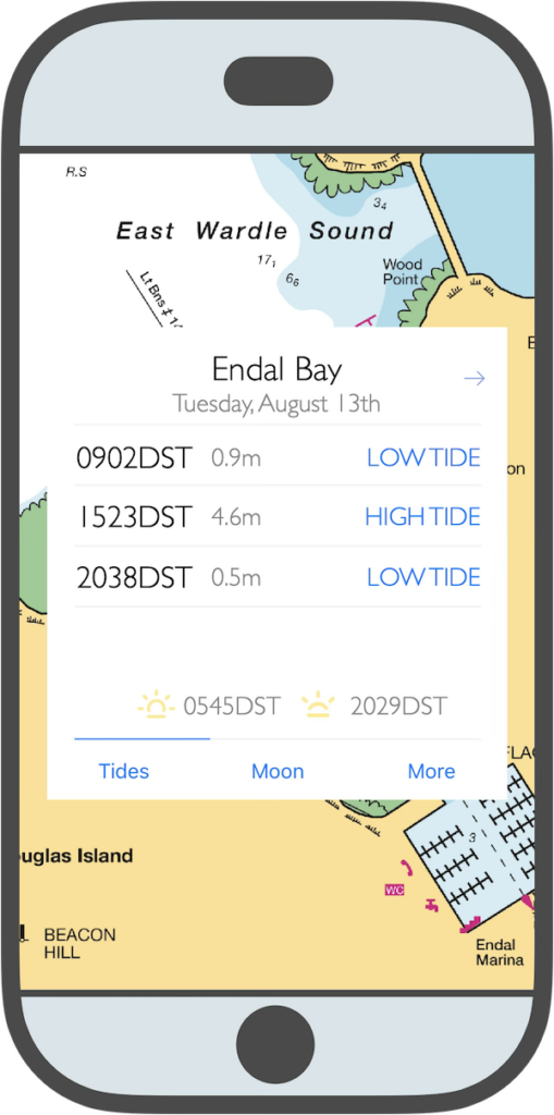
This is where the RYA Digital First approach makes sense. It is not “ditch the old skills”. It is “use modern tools because that is what skippers actually use”. The skill shift is subtle but important.
The new skipper skill: confidence, not confirmation
Digital tools create a new trap. You can get an answer quickly, then treat it as truth without asking where it came from.
If you look hard enough, you will always find a forecast that suits your plan. That is not good seamanship. What you need is confidence in the information.
A modern version of “using the Almanac” looks like this:
That is Digital First done properly. You use the tools. You keep responsibility.
So why does the Nautical Almanac still exist
Despite all this progress, the Nautical Almanac still gets published every year. That is not nostalgia. It is redundancy. Offshore, electronics can fail. Batteries die. Antennas break. Saltwater finds its way into everything eventually.
The Almanac reminds us of a broader point. Navigation is not about the tool. It is about the method, the cross-checks, and the habit of making decisions for reasons.
A legacy written in the stars
The Nautical Almanac quietly changed seamanship. It turned an impossible problem into a solvable process. It gave navigators a trusted reference at sea.
Today we have faster tools, but the responsibility sits in the same place. The skipper still must validate, cross-check, and decide.
So yes, enjoy your chartplotter. Use your apps. But keep one old-school habit alive. Ask where the information came from, and how confident you are in it. That single habit has kept sailors safe for centuries, whether the answer came from a printed table or a glowing screen.